


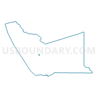
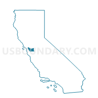
Voting District 20800, Alameda County, California
About
Outline

Summary
| Unique Area Identifier | 528707 |
| Name | Voting District 20800 |
| County | Alameda County |
| State | California |
| Area (square miles) | 0.15 |
| Land Area (square miles) | 0.15 |
| Water Area (square miles) | 0.00 |
| % of Land Area | 100.00 |
| % of Water Area | 0.00 |
| Latitude of the Internal Point | 37.63076400 |
| Longtitude of the Internal Point | -122.02014620 |
Maps

Graphs
Select a template below for downloading or customizing gragh for Voting District 20800, Alameda County, California


Neighbors
Neighoring Voting District (by Name) Neighboring Voting District on the Map
- Voting District 20530, Alameda County, CA
- Voting District 20740, Alameda County, CA
- Voting District 20755, Alameda County, CA
- Voting District 20815, Alameda County, CA
- Voting District 20845, Alameda County, CA
Top 10 Neighboring County Subdivision (by Population) Neighboring County Subdivision on the Map
Top 10 Neighboring Place (by Population) Neighboring Place on the Map
Top 10 Neighboring Unified School District (by Population) Neighboring Unified School District on the Map
- Hayward Unified School District, CA (165,923)
- New Haven Unified School District, CA (74,171)
- Castro Valley Unified School District, CA (49,397)